FOR DMC`s ONLY
OUR ADVENTURES


The iconic .xx. shaped boulder
Activity: Hike, bathing in pothole
Difficulty: Medium
Lenght: Full day, 7,5 km
Content: Geology, nature
Highlights: Pothole and Trollpikken



ADVENTURES
HÅDYR

HALF DAY ADVENTURE HIKE
-
Easy to medium difficulty
-
2,6 km return hike
-
Viking history
-
Geological history (Magma UNESCO Global Geopark)
-
Highlight: the view, unlike anything in Norway
Marked trail through wild coastal landscape. Short scrambling in the mid-section. One of the most dramatic and stunning views in Magma UNESCO Global Geopark. Historic landmark.


HÅDYR-NESVÅG
FULL DAY ADVENTURE HIKE
-
Medium to hard
-
5 km
-
Hiking
-
Viking & WWII history
-
Geological history (Magma UNESCO Global Geopark)
-
Highlight: Hådyr, Vatlandsvik and Nesvåghålo
Trail through wild coastal landscape. The view from the mountain Hådyr is spectacular and it is connected to Norwegian Viking history. The unmarked path going south from Hådyr is partially wet and contains some scrambling. We follow the rugged coastline and might meet wild sheep or eagles.
The dramatic WW2 history of Vatlandsvik, a small bay along the trail, is worth exploring. Depending on weather and sea conditions wild swimming might also be possible here.
At the end of the hike, we visit the unique pothole Nesvåghålo. This is a well-known instaspot.


JAMES BOND ISLAND

HALF DAY ADVENTURE
-
Hard
-
Activity: Scrambling, heights, ladders
-
Boat transportation included
Small and isolated island south of Egersund. Spectacular and wild landscape. Potholes. Views. Lighthouse. Caves. In the heart of Magma UNESCO Global Geopark. WW2 history: connected to James Bond in a peculiar way.


AUGLEND
HALF OR FULL DAY ADVENTURE
-
Easy to medium difficulty
-
Activity Hiking, rappel, wild swimming
-
Highlight: “Hjertejettegryten”
Area suggested as “Norway’s smallest national park” due to diversity above and under the sea. Hiking in typical and exposed south-western coastal landscape. Possible to include rappel and wild swimming, and a visit to Instaspot Hjertejettegryten (heart shaped pothole).


EIGERØY LIGHTHOUSE
HALF DAY ADVENTURE
-
Easy
-
Activity: hiking, wild swimming, biking (?)
-
4,6 km return
-
Coastal history
-
WWII and Cold War history
-
Geological history (Magma UNESCO Global Geopark)
-
Highlight: the Lighthouse
First part of the hike is on gravel road leading to a stunning viewpoint. The second part is on marked trail leading to Eigerøy lighthouse and the coastline. Exclusive access to the lighthouse is possible. Wild swimming is possible on this hike.
If biking from Egersund, add 10 km one way on tarmac.


JØSSINGFJORD-SOKNDALSSTRAND
FULL DAY ADVENTURE
-
Hard; but with optional activities. Hike is medium difficulty but long.
-
6,5 km
-
Activity: Hiking, Via ferrata and/or rappel
-
Lunch in Tunnelstuo (the Tunnel)
-
Geological history (Magma UNESCO Global Geopark)
-
WW2
-
Highlight: Kolbolten... and basically everything
Jøssingfjord is where Norway first got involved in WW2, due to circumstances connected to Winston Churchill og UK. This is also where we have some of the oldest settlements in the geopark. Jøssingfjord is well known amongst international climbers for having some of the most challenging climbing walls, and the rocks are hard, rough and typical for Magma Geopark.
We can climb the established Via Ferrata Migaren or offer rappelling from Tunnelstuo, translated into “tunnel living room”. The rappel is about 60 meters long. After eating brought lunch in Tunnelstuo, we hike towards the picturesque village of Sogndalstrand. Passing the challenging Kolbolten on our way. This is a bolder caught between to mountains, and it is a challenge for the brave ones to step out on the boulder and get that ever so important photographic proof.
The hike between Jøssingfjord and Sogndalstrand is beautiful. Following the fjord for a few kilometers, heading inland to typical wild coastal landscape and ending up at the rugged coastline.


HELLERSHEIA
FULL DAY ADVENTURE
-
Hard
-
5,5 km
-
Activity: Hiking, Via Ferrata UNDERGROUND and/or rappel
-
Lunch in Tunnelstuo (the Tunnel)
-
Geological history (Magma UNESCO Global Geopark)
-
WW2
-
Highlight: the rim, the view and the underground via ferrata.
Hellersheia is a mountain range above Jøssingfjord. The hike is steep, but you are rewarded with beautiful 360 degrees views over the fjord and the typical geopark landscape. On our way down into the fjord, we will be passing the impressive “Profilveggen” where you can meet professional climbers, and hike through huge boulders left by enormous glacial rivers ten thousand years ago. Also possible to do the underground via ferrata. Or offer rappelling from Tunnelstuo, translated into “tunnel living room”. The rappel is about 60 meters long


TROLLPIKKEN
FULL DAY ADVENTURE
-
Medium difficulty
-
7,5 km
-
Activity: Hiking, wild swimming in potholes
-
Geological history (Magma UNESCO Global Geopark)
-
Highlight: Trollpikken and potholes
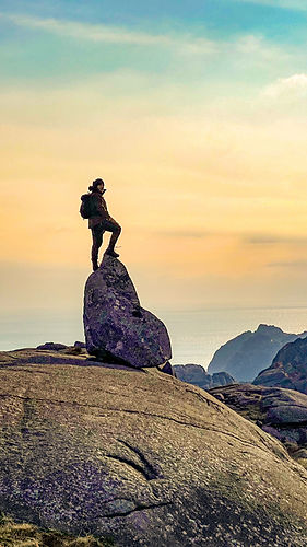
Trollpikken became world famous when someone decided to cut down this phallic rock formation. The stunt resulted in huge international exposure and the start of an enormous wave of tourists visiting the area. Today this is one of the most visited attractions in south-west Norway.
The hike to Trollpikken is rather short, but takes us through a wild, and to many, unknown kind of landscape. To add to the experience, this hike goes all the way back to Egersund city center. The hike takes us through remoted areas and wilderness, passing small lakes, heather, peat, small wooden valleys and playful streams. The entrance to Egersund, is via Vannbassengan. This is a beloved recreational area for locals and visitors, with a huge number of trails, picnic areas and lakes for sunbathing and swimming.
When the conditions are right, it is also possible to take a bath in the natural spa provided by running water and potholes – shaped 10 000 years ago under the massive ice covering the area


MÅNAFOSSEN & BOULDER VIA FERRATA
FULL DAY ADVENTURE
-
Medium difficulty
-
3 km
-
Activity: Scenic drive, via ferrata, hiking, wild swimming if desirable.
-
Geological history
-
Highlight: 90 meter waterfall, largest boulder field in northern Europe, Via Ferrata, scenic drive, fjord
This is a incredible scenic drive from Egersund to the largest boulder field in northern Europe. Here we do a 1 hour via ferrata (optional). Continue to the 90 meter waterfall of Månafossen where we hike to the old farm above the waterfall. We have fjord views and an opportunity to swim in a norwegian fjord.


THE PULPIT ROCK
FULL DAY ADVENTURE
-
Medium to demanding hike
-
8,5 km
-
Activity: hike
-
Geological wonder, fjord view
-
Highlight: the Pulpit Rock
Preikestolen (The Pulpit Rock) towers 604 metres above the Lysefjord. The trek to the rock is one of Norway’s most famous mountain hikes. Preikestolen is very popular, with more than 300,000 nature-loving hikers visiting the renowned rock formation every year.


THE BEACHES
FULL OR HALF DAY ADVENTURE
-
Easy hike
-
5-10 km
-
Activity: hike
-
Miles and miles with beaches
-
Highlight: Beaches and lagoons
Forget fjords... this is all about horizon, skies and endless beaches. We take the train to and from Egersund to the beaches. We hike along the most beautiful coastline and longest beaches in Norway. Beaches, salmon rivers, small bays and lagoons. Just amazing!


